
Current Water Conditions in Medford
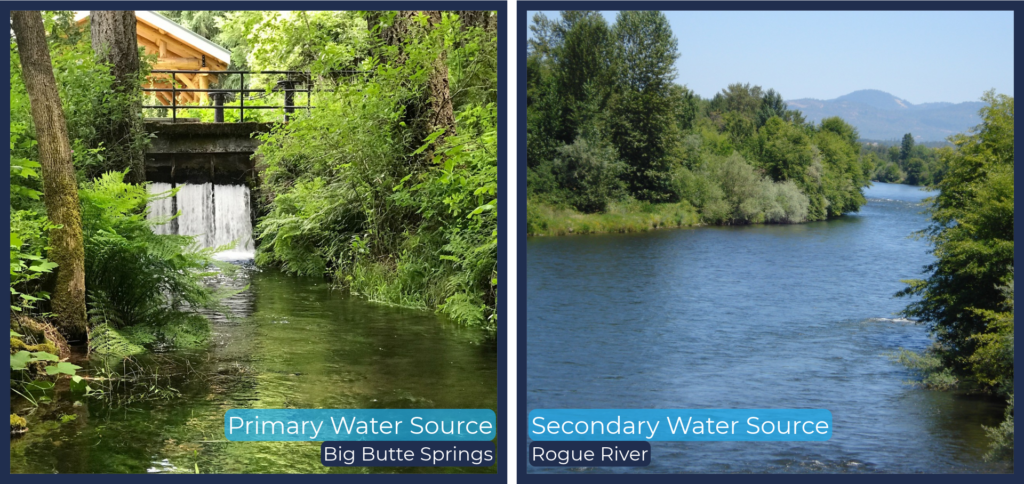
Medford Water works diligently to ensure that safe drinking water is available for the approximately 150,000 residents of the Rogue Valley that we serve, in Medford, Central Point, Eagle Point, Jacksonville, Phoenix, Talent, Ashland, the unincorporated community of White City, and the Elk City Water District. Our ability to supply water from two different sources helps to maintain reliability and redundancy: our primary source is Big Butte Springs, and the Rogue River is our secondary source used during peak demand months. Fortunately, it takes several years of compounded low precipitation and snow levels to impact these sources.
Find information about how we’re managing current water supply and demand, FAQs, area water supply conditions, what you can do to help, and additional resources on the bottom of the page.
WATER SUPPLY UPDATES
Water Year 2026-2027
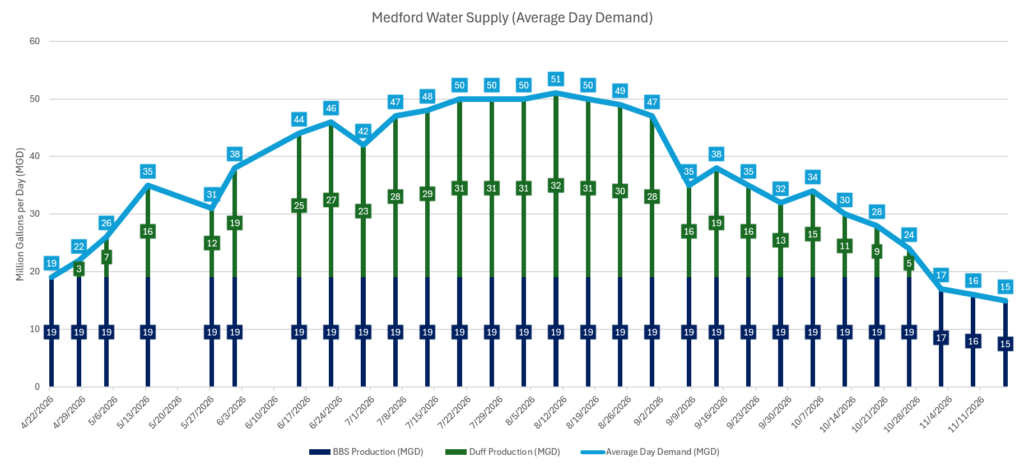
The table will be updated throughout the year with information about how Medford Water is utilizing its water sources to reliably serve our customers clean drinking water in the most efficient and responsible way possible (it may be viewed better on a desktop browser). During the peak water demand months, demand is met through a combination of both of our sources.
| Date | Water Production | Water Demand (Use) | Customer Actions |
| November 16, 2026 | • Big Butte Springs (BBS): 15 MGD • Rogue River (via the Duff Drinking Water Treatment Plant): 0 MGD. • Total river flows: 1,220 cfs. | • Current demand is 15 MGD; this is within the normal demand for November, which ranges from 15-20 MGD. • Demand is being met with our Big Butte Springs source. | There is sufficient supply to meet the needs of the communities we serve. However, we urge all water users to be mindful of their usage as we go into the summer season. If you are interested in learning more ways to use water more efficiently, here are some helpful tips. |
| November 9, 2026 | • Big Butte Springs (BBS): 16 MGD • Rogue River (via the Duff Drinking Water Treatment Plant): 0 MGD. • Total river flows: 1,180 cfs. | • Current demand is 16 MGD; this is within the normal demand for November, which ranges from 15-20 MGD. • Demand is being met with our Big Butte Springs source. | There is sufficient supply to meet the needs of the communities we serve. However, we urge all water users to be mindful of their usage as we go into the summer season. If you are interested in learning more ways to use water more efficiently, here are some helpful tips. |
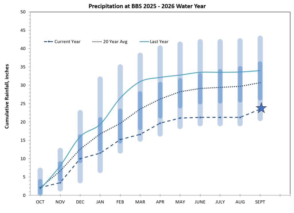
Big Butte Springs 23.46 inches: 23% Below Normal
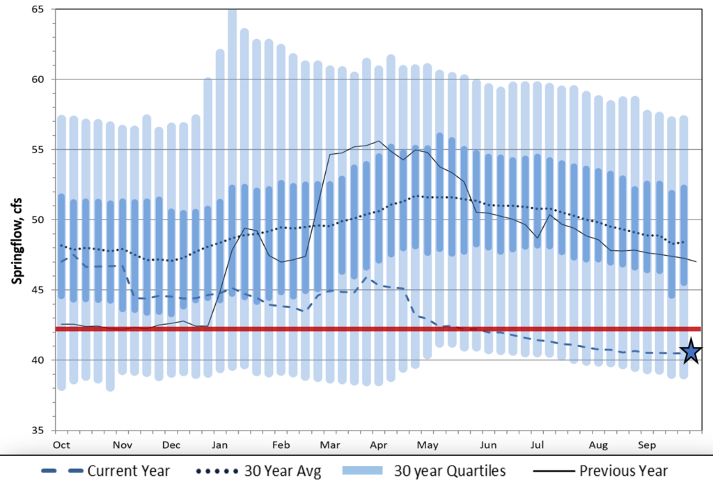
Currently at pipe and a half: Producing approximately 19 MGD
Spring flows were not quite enough to fill two full pipes this summer
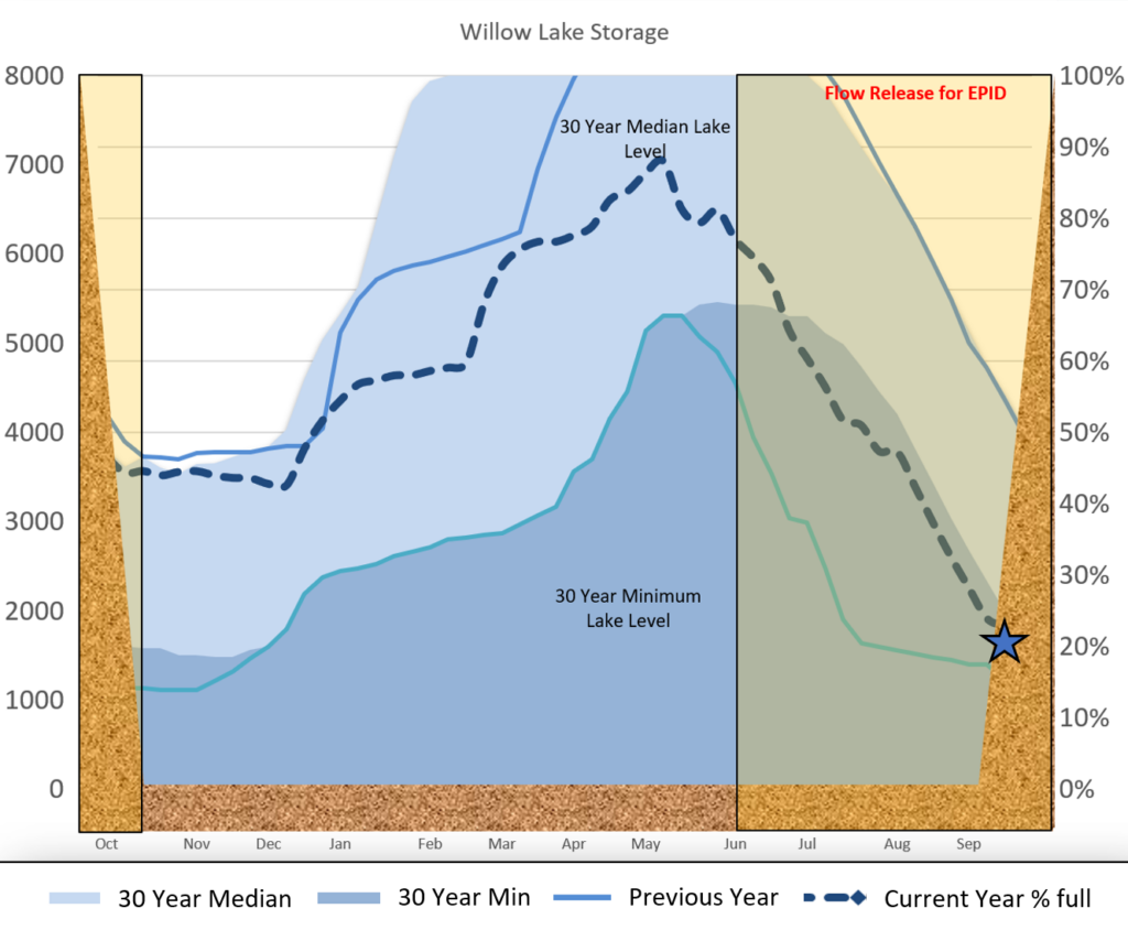
Willow Lake Storage 2025-2026 Water Year
Willow Lake is owned and operated by Medford Water and was constructed to store water for Eagle Point Irrigation District (EPID) to use for irrigation purposes.
- EPID irrigation season April 22nd – Sept. 9th
- Started the Water Year at 3,550-acre feet
- Ended Water Year at 1,750-acre feet
Medford Precipitation Report
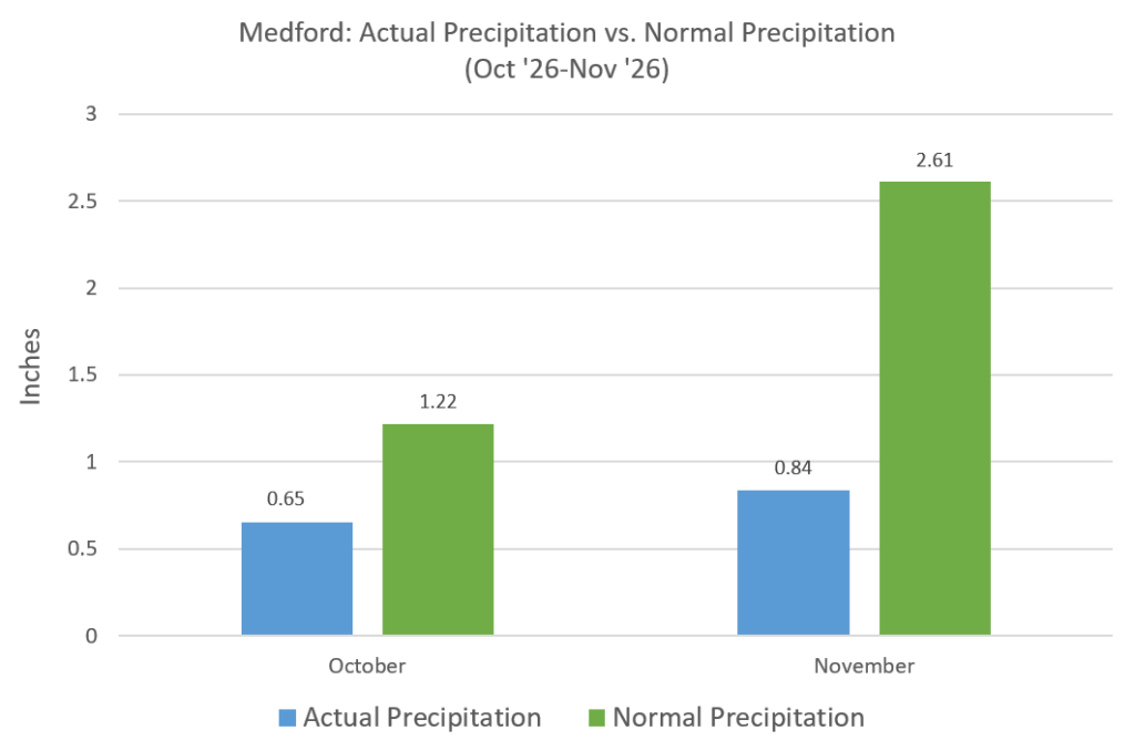
Precipitation in Medford is at 2.06 inches, approximately 33% below normal for the water year (October 1, 2026 to September 30, 2027). Fortunately, it takes several years of compounded low precipitation to impact our water sources.
This data is collected at the Rogue Valley International Airport (Elevation: 1,312 ft.); precipitation levels around the Rogue Valley will vary depending upon the location.
The National Weather Service has an in-depth map to reference as another resource.
Snowpack Report
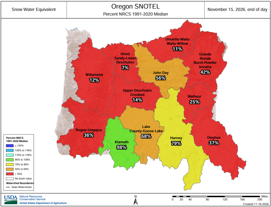
The National Resource Conservation Service monitors snowpack in stream basins. Currently, every basin across the state is measuring well below the historical median (min = 0%, max = 30%). Statewide Snow Water Equivalent in the Rogue-Umpqua Basin is measuring 36% of the historical median. Fortunately, it takes several years of compounded low snow levels to impact our water sources.
If you would like to see the levels across the state, go to the Natural Resources Conservation Service.
Irrigation Reservoir Levels
Reservoir storage in most basins across the state are near normal for this time of year; on the right are reservoir levels in our region. The diagrams represent the level of fill in the reservoirs as both percent full and as a ratio of volume of water currently in the reservoir to the volume of water in the reservoir when it is full.
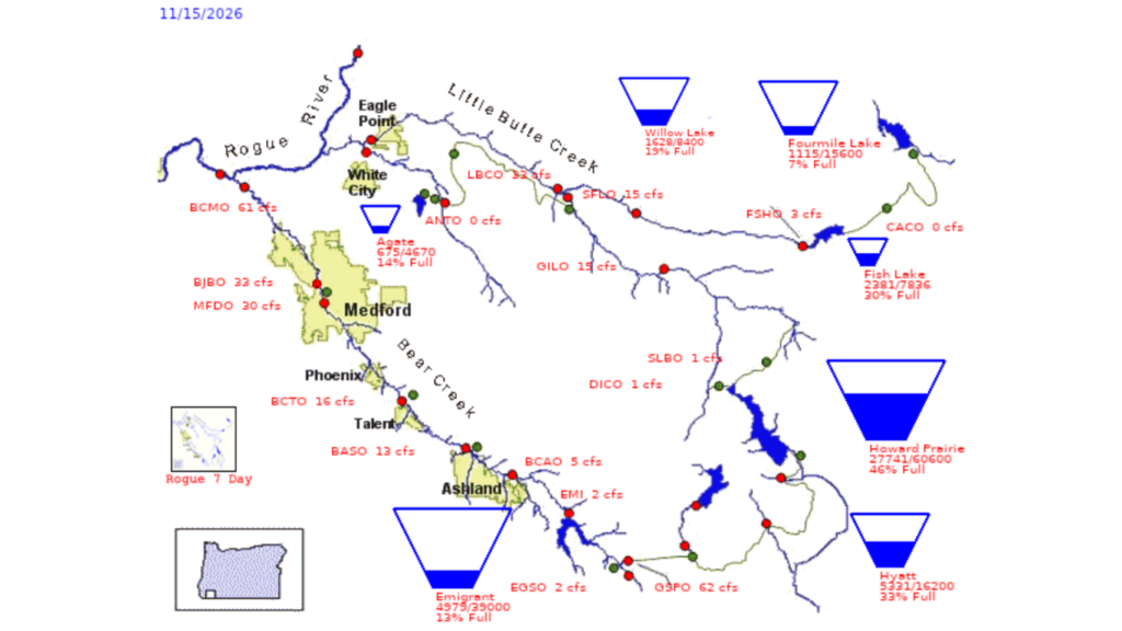
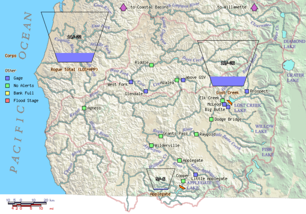
Rogue Basin Teacup Diagram
While the reservoirs in the Bear Creek and Little Butte Creek Basins (pictured above) are primarily for irrigation, the reservoirs in the Rogue Basin (pictured left) are managed by the US Army Corps of Engineers and are primarily for flood control and fish and wildlife conservation.
THE STATE OF DROUGHT
The Jackson County Board of Commissioners requested an emergency drought declaration from the state on April 1, 2026, and on April 24, 2026, Governor Kotek declared a drought emergency in Jackson County. Click here to see the Governor’s Executive Order.
According to the US Drought Monitor, most of Jackson County is experiencing severe drought (D2).
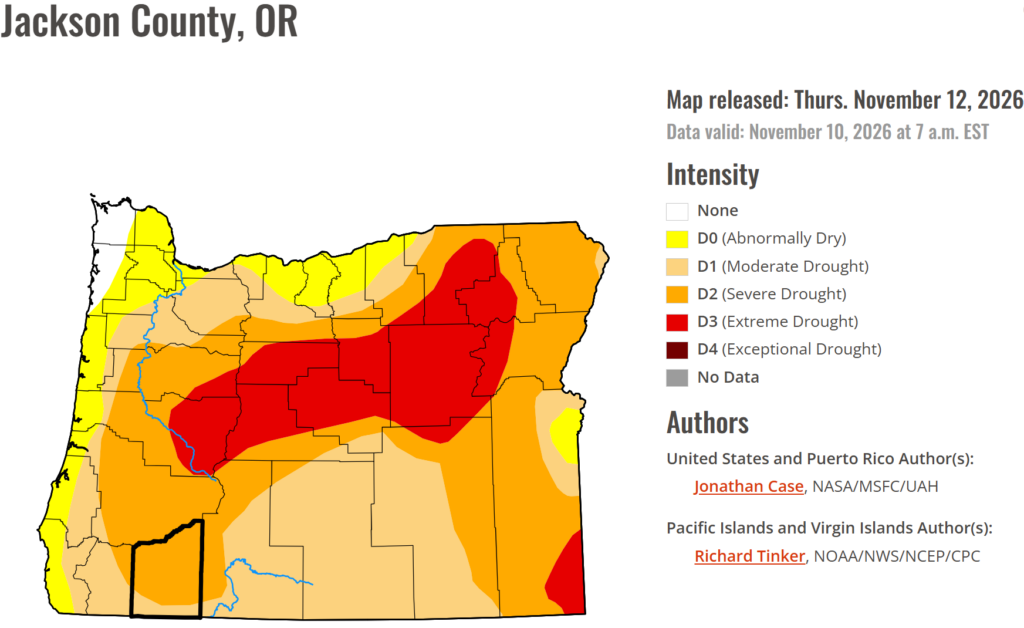
The drought declaration process typically goes through a three-part process before securing a state drought declaration from the Governor:
- First, a county commission submits a request for a state drought declaration to the Office of Emergency Management.
- Second, the Water Availability Committee, chaired by the Water Resources Department, meets to evaluate information on weather and water supply conditions and subsequently make recommendations to Oregon’s Drought Council. The Drought Council assesses the impact of drought conditions and makes recommendations to the Governor’s Office on whether to declare drought in an area.
- The Governor may then choose to issue an Executive Order declaring a drought emergency. State drought declarations are typically issued at a county scale. The primary benefits of a state drought declaration from the Governor are that it creates greater awareness of drought conditions, facilitates coordination between state agencies, and allows the Water Resources Department to provide existing water right holders with access to emergency water management tools.
The Governor or the Oregon Water Resources Commission can also direct state agencies and political subdivisions to implement a water conservation plan or water curtailment plan. Factors for declaring drought include precipitation, temperature, streamflow, reservoir levels, and soil moisture. A Drought Declaration provides greater awareness of drought conditions, access to emergency tools for water rights holders, short-term emergency authorizations (rather than permanent), and priority for drinking water and stock watering.
Additional Resources
Customers looking for more information about drought conditions and water use can visit several resources. For statewide drought declarations, current conditions, and water data, visit the Oregon Water Resources Department website at oregon.gov. Information about agricultural water availability can also be found through local irrigation districts serving Jackson County.
For more information on the local and regional water supply outlook, you can also explore some of these resources:
Questions?
Call 541-774-2430 for more information.